Satellite Tracking
FBSAT59 provides real-time satellite position tracking with accurate orbital predictions using Skyfield ephemeris calculations.
Real-Time Position Display
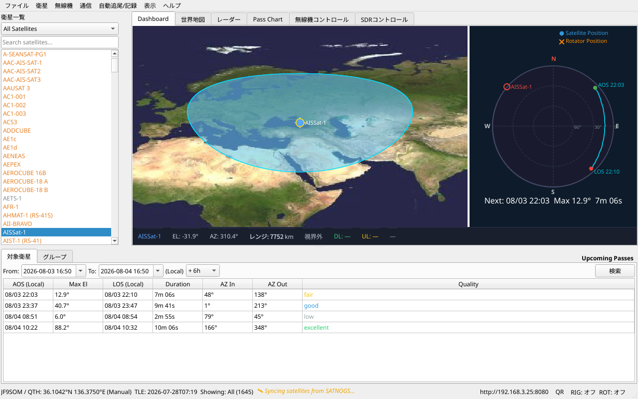
Dashboard Map
The Dashboard tab displays a world map with current satellite positions:
- Green dots — Satellites currently above the horizon at your location
- Gray dots — Satellites currently below the horizon
- Red line — Your satellite's ground track (if selected)
Click any dot to select that satellite. The map updates every second.
Radar Display
A sky-view radar shows satellites relative to your location:
- Concentric circles — Elevation angles (0° horizon to 90° zenith)
- Compass directions — North/South/East/West
- Colored dots — Satellite positions with names
- Curved lines — Complete satellite pass trajectory (AOS to LOS)
Mobile Compass Mode
When accessed from a smartphone with a gyroscope, the radar automatically rotates to match your device's orientation (like a compass).
Pass Prediction
FBSAT59 calculates all upcoming satellite passes visible from your location.
View Pass Predictions
- Select a satellite from the left sidebar
- Click Passes tab
- View upcoming passes with:
- AOS Time — Acquisition of Signal (rise time)
- LOS Time — Loss of Signal (set time)
- Max Elevation — Highest point in the sky
- Duration — How long the satellite is visible
Pass Quality
Each pass is rated by maximum elevation:
| Quality | Elevation | Color |
|---|---|---|
| Excellent | 60°+ | 🟢 Green |
| Good | 30°-60° | 🔵 Blue |
| Fair | 10°-30° | 🟡 Yellow |
| Low | <10° | ⚪ Gray |
Higher elevations = better signal strength for communication.
Pass Chart
The Pass Chart tab shows a graphical view of satellite elevation vs. time:
- X-axis — Time (AOS to LOS)
- Y-axis — Elevation angle (0° to 90°)
- Curve — Satellite elevation over time
- Red vertical line — Current time
Useful for planning radio sessions and photography.
Upcoming Passes
View All Upcoming Passes
- Click Passes tab
- Select All Satellites or a specific group (Amateur, Weather, etc.)
- Choose a date range (next 7 days, 30 days, etc.)
- A table shows all visible passes, sorted by quality
Favorite Groups
Organize satellites into custom groups:
- View menu → Manage Favorites
- Create new group (e.g., "ISS Passes")
- Add satellites to group
- Filter Passes tab to show only your group
TLE (Two-Line Element) Data
FBSAT59 uses TLE data to calculate orbital positions. TLE data is typically 1-2 days old.
Automatic TLE Updates
FBSAT59 automatically fetches fresh TLE data from multiple sources:
- CelesTrak — Primary source (Amateur, Weather, CubeSats, etc.)
- Space-Track.org — Backup (requires account, optional)
- AMSAT — Amateur satellite operations status
Updates occur automatically based on satellite category:
| Category | Update Interval |
|---|---|
| Space Stations (ISS, CSS) | 1 hour |
| Amateur Satellites | 2 hours |
| CubeSats | 4 hours |
| Weather Satellites | 6 hours |
| Earth Observation | 12 hours |
Manual TLE Update
To force an immediate update:
- Satellite menu → Fetch TLE Data
- Or Settings → Data Sync → Fetch TLEs
- FBSAT59 fetches the latest TLE from CelesTrak
TLE Quality Status
View current TLE freshness:
- Help menu → TLE Status
- Shows age of each source's data (excellent <6h, good <24h, fair <72h, poor)
Satellite Database
FBSAT59 includes a built-in database of 5000+ satellites. The database includes:
- Amateur Radio Satellites — Cubesats, transponders, beacons
- Weather Satellites — NOAA, METEOR, Metop
- Earth Observation — Landsat, Sentinel
- Scientific Missions — Solar observers, deep space probes
- Space Stations — ISS, Chinese Space Station
- Debris Tracking — International Space Station fragments
Search Satellites
- In the left sidebar, use the search box to filter by name
- Type partial name (e.g., "ISS" or "NOAA")
- Results update in real-time
Transmitter Frequencies
For each satellite, FBSAT59 displays available transmitters:
- Select a satellite
- View Transmitters panel (right sidebar)
- Shows:
- Downlink frequency (what you receive)
- Mode (FM, SSB, CW, PSK, etc.)
- Bandwidth (if known)
- Status (Active, Inactive, Unknown)
SATNOGS Integration
FBSAT59 syncs transmitter data from SATNOGS.org:
- Fetches frequency database automatically
- Manually add or edit frequencies
- Manual frequencies override SATNOGS data
- Export/import frequency lists
Doppler Tuning
When a satellite transmits while moving toward/away from you, its frequency shifts (Doppler effect).
Automatic Doppler Correction
When you select a satellite in Radio Control tab:
- FBSAT59 calculates the Doppler shift in real-time
- Downlink frequency is automatically adjusted
- Your radio locks onto the satellite signal
For example: NOAA 18 transmits at 137.9125 MHz, but as it moves toward you, FBSAT59 tunes to +2.5 kHz higher to compensate.
Doppler Lock
Use the L (Lock) button in Radio Control to enable/disable Doppler tuning:
- [L] ON — Doppler tuning active (frequency changes automatically)
- [L] OFF — Fixed frequency (manual tuning only)
Multipath Prediction
For advanced users: FBSAT59 predicts favorable propagation windows for:
- Moonbounce (EME) — Moon reflection propagation
- Ionospheric propagation — Suitable passes for HF satellites
These features require additional antenna equipment and are marked in the Pass list.
Location Settings
Satellite tracking accuracy depends on your location coordinates.
Update Your Location
- Settings → Location
- Enter coordinates as:
- Decimal degrees (35.6762, 139.6503)
- Maidenhead grid locator (PM95aq)
- GPS (if available)
- Click Save
Changing location immediately updates all pass predictions and radar displays.
Next Steps
- Radio Control — Command your radio based on satellite position
- Communications — Decode satellite telemetry
- Web Interface — Track from your smartphone